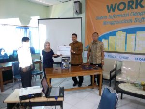
Jumat, 13 Oktober 2017 Departemen Teknik Geodesi bekerja sama dengan SuperMap Software co Ltd telah mengadakan acara Workshop dengan Tema “Sistem Informasi Geografis dan Analisis 3D menggunakan Software SuperMap”. Acara yang diadakan di Gedung Kuliah Bersama (GKB) Fakultas Teknik Lantai 3 ini dihadiri kurang lebih 57 peserta yang merupakan perwakilan dari BPN/ATR, BPDAS, instansi pemerintah (SKPD), dari tingkat Provinsi Jawa tengah Kota semarang, Kabupaten Kendal, Kabupaten Demak, Kabupaten Semarang, kota Salatiga, kota Pekalongan dan Kabupaten Boyolali. Selain itu acara ini juga dihadiri oleh perwakilan Departemen di Fakultas Teknik Universitas Diponegoro.
 Acara ini bertujuan untuk menjalin kerjasama antara Fakultas Teknik Universitas Diponegoro dengan SuperMap Software co Ltd. Selain itu dengan diadakannya acara ini, diharapkan peserta dapat menambah pengetahuan tentang SuperMap Software dan cara pengaplikasiannya. Acara ini diadakan pada pukul 07.30 WIB – 16.00 WIB dengan menghadirkan pembicara Senior Technical Enggineer SuperMap International yaitu Mr. Jayson Yuan. Acara ini dimulai dengan penandatanganan kerjasama antara Fakultas Teknik Universitas Diponegoro dengan SuperMap Software co Ltd dan penyerahan simbolis licenced software SuperMap iDesktop yang diterima oleh Dekan Fakultas Teknik Universitas Diponegoro bapak Ir. M. Agung Wibowo, M.M,. M.Sc,. P.hD . Software SuperMap ini dapat dimanfaatkan untuk analisa geospasial di laboratorium computer dan SIG di lingkungan Fakultas Teknik Universitas Diponegoro. Workshop pada kali ini berjalan lancar dan kondusif, peserta sangat antusias dalam mengikuti materi dan exercise yang disampaikan oleh Mr. Jayson Yuan. Materi workshop kali ini terdiri dari materi 1 : Digitizing, materi 2 : 3D Building From Paper Map, materi 3 : Oblique Photogrametry 3D Training, materi 4 : 3D Analysis Training, materi 5 : Showing 3D BIM in SuperMap , dan diakhiri dengan foto bersama.


